Showing 9238 items
matching north warrandyte
-
 Eltham District Historical Society Inc
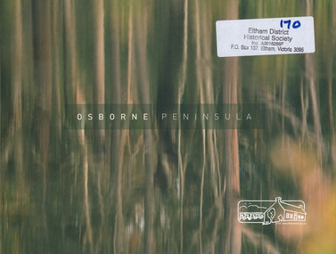
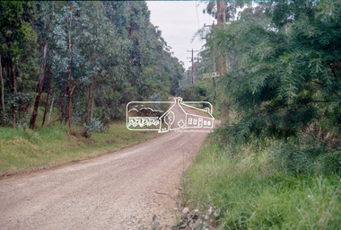
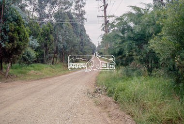
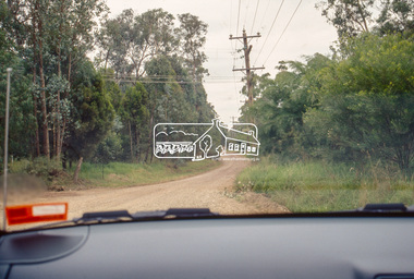
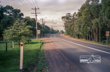
Book, North Warrandyte Landcare Group, Osborne Peninsula prepared by North Warrandyte (Osborne Peninsula) Landcare Group Inc, 2009
... Osborne Peninsula prepared by North Warrandyte (Osborne...north warrandyte history...History of North Warrandyte Osborne Peninsula...North Warrandyte Landcare Group ... melbourne History of North Warrandyte Osborne Peninsula north ...History of North Warrandyte Osborne Peninsula39 p. : ill., map ; 20 x 27 cm.[pasted inside front cover is a typed letter promoting the book addressed to "Dear Resident", dated 2nd August 2009] north warrandyte history, yarra river, osborne peninsula warrandyte -
 Eltham District Historical Society Inc
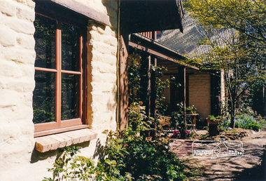
Photograph, Gayle Blackwood, Robert Marshall designed mudbrick home, off Warrandyte-Research Road, North Warrandyte
... -Research Road, North Warrandyte...North Warrandyte...Warrandyte-Research Road, North Warrandyte... melbourne houses mudbrick Warrandyte-Research Road North Warrandyte ...Ten colour prints 10 x 15 cmhouses, mudbrick, warrandyte-research road, north warrandyte, gayle blackwood collection, robert marshall -
 Eltham District Historical Society Inc
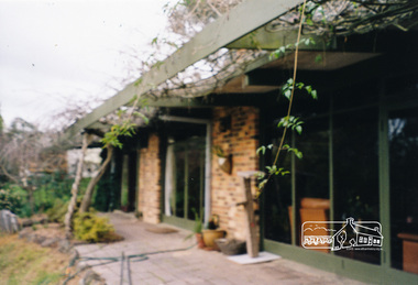
Photograph, Gayle Blackwood, Alistair Knox designed mudbrick home, off Warrandyte-Research Road, North Warrandyte
... -Research Road, North Warrandyte...north warrandyte...Warrandyte-Research Road, North Warrandyte, Victoria... melbourne houses mudbrick warrandyte-research road north warrandyte ...Five colour prints 10 x 15 cmhouses, mudbrick, warrandyte-research road, north warrandyte, gayle blackwood collection, alistair knox -
 Eltham District Historical Society Inc
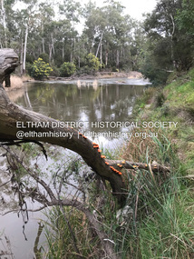
Photograph, Fay Bridge, Yarra River near the eastern boundary of former Warrandyte Aboriginal Reserve, North Warrandyte, 11 August 2023
... Aboriginal Reserve, North Warrandyte...North Warrandyte...Accessed via The Boulevard, North Warrandyte... melbourne Accessed via The Boulevard, North Warrandyte Fay Bridge ...Accessed via The Boulevard, North Warrandytefay bridge collection, aboriginal reserve, north warrandyte, warrandyte aboriginal reserve, 2023-08-11 -
 Eltham District Historical Society Inc
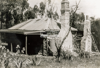
Photograph - Black and White Print, Old settler's cottage, Floods Lane, North Warrandyte, c.1935
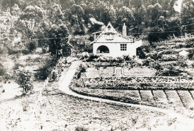
... Old settler's cottage, Floods Lane, North Warrandyte...North Warrandyte... Road off Kangaroo Ground-Warrandyte Rd near boundary of North... Road off Kangaroo Ground-Warrandyte Rd near boundary of North ...An early settler's cottage of 1920s vintage near Floods Rd taken in the 1930s. Was originally Floods Lane and became Floods Road off Kangaroo Ground-Warrandyte Rd near boundary of North WarrandyteInscribed in pencil on reverse "early 20's near Flood Rd taken 30's. 21/1.89" and in pen ".16/1.80"cottage, floods lane, floods road, houses, kangaroo ground-warrandyte road, north warrandyte, pioneers -
 Eltham District Historical Society Inc
Photograph, Fay Bridge, Eastern boundary of former Warrandyte Aboriginal Reserve, North Warrandyte, 7 November 2016
... , North Warrandyte...North Warrandyte... of the former Warrandyte Aboriginal Reserve on the north and south sides... of the former Warrandyte Aboriginal Reserve on the north and south sides ...Two bronze commemorative plaques on rocks, unveiled by Wurundjeri Tribe Council Elders, mark two eastern boundaries of the former Warrandyte Aboriginal Reserve on the north and south sides of the Yarra. This project was initiated by Nillumbik Reconciliation Group in close association with Reconciliation Manningham and the Wurundjeri Tribe Council, as a means of commemorating the last great corroboree of the Kulin Nation which was held at Pound Bend in March 1852. This plaque is on the Nillumbuk side of the Yarra, accessed via The Boulevard, North Warrandyte. The plaque is set on a rock approximately 50 metres before the turning circle at the end of The Boulevard. Plaque : Warrandyte Aboriginal Reserve This commemorative rock marks an eastern boundary of the former Warrandyte Aboriginal Reserve established in 1852. Centred on Pound Bend, it covered 1,908 acres on both sides of the Yarra River (Birrarung). That same year saw the last great gathering of the Kulin nation here in Wurundjeri country which was celebrated over two weeks with traditional performance and games. For a few years longer the reserve intermittently served as a ration station.With gold having been discovered at Warrandyte, the Wurundjeri were moved on again but ultimately secured a permanent home at Coranderrk, Healesville. A second commemorative plaque and rock is located on the opposite bank of the Yarra and its confluence with Stony Creek. Melway ref : 23 C 9 Unveiled by Wurundjeri Elder, Uncle Bill Nicholson on 23rd March 2013 Funded by the Robert Bridgford Indigenous Trust (Nillumbik Community Fund) with assistance from Manningham City Council Small Grants Program Ref: Monument Autralia https://monumentaustralia.org.au/themes/culture/indigenous/display/99680-warrandyte-aboriginal-reserve-fay bridge collection, 2016-11-07, aboriginal reserve, north warrandyte, plaques, warrandyte aboriginal reserve -
 Eltham District Historical Society Inc
Photograph - Digital Photograph, Alan King, The Robins, 13 Kangaroo Ground-Warrandyte Road, North Warrandyte, 2 March 2008
... The Robins, 13 Kangaroo Ground-Warrandyte Road, North...North Warrandyte... Kangaroo Ground-Warrandyte Road North Warrandyte The Robins Born ...Built by noted artist Theodore Penleigh Boyd, father of architect Robin Boyd. Covered under National Estate, National Trust of Australia (Victoria) Local Significance and Heritage Overlay, Nillumbik Planning Scheme. Published: Nillumbik Now and Then / Marguerite Marshall 2008; photographs Alan King with Marguerite Marshall.; p111This collection of almost 130 photos about places and people within the Shire of Nillumbik, an urban and rural municipality in Melbourne's north, contributes to an understanding of the history of the Shire. Published in 2008 immediately prior to the Black Saturday bushfires of February 7, 2009, it documents sites that were impacted, and in some cases destroyed by the fires. It includes photographs taken especially for the publication, creating a unique time capsule representing the Shire in the early 21st century. It remains the most recent comprehenesive publication devoted to the Shire's history connecting local residents to the past. nillumbik now and then (marshall-king) collection, kangaroo ground-warrandyte road, north warrandyte, the robins -
 Eltham District Historical Society Inc
Photograph, Fay Bridge, Former Glynn's Dairy Farm, Glynns Road, North Warrandyte, 31 August 2018
... Former Glynn's Dairy Farm, Glynns Road, North Warrandyte...North Warrandyte... Road North Warrandyte Parks Victoria Ruins Riverswood Kenneth ...Glynn’s farm Originally Section 7, Parish of Nillumbik marked Aborigine Reserve in 1866 Crown Allotment 8, Section 7, Parish of Nillumbik, County of Evelyn, Certificate of Title Volume 4095, Folio 818.835, approx. 93 acres purchased by Joseph Panton in 1881 for £1/acre and known as Panton’s Point. By 1924 owned by S.S. Sergeant and called Riverswood. Sergeant commissioned Edna Walling to design the garden. In September 1929 the property was sold at auction by Mortgagee’s sale. Described as well built, brick, tile roof, Attic Villa containing downstairs 7 good rooms, bath, scullery, inside lavatory, etc. Upstairs 2 bedrooms and sleep out. Outbuildings compromising of brick and weatherboard wash house, stables, workshop, feed room, cow bails, large G.I. Hay shed, etc In January 1931 Riverswood property was proclaimed a sanctuary for native game for the entire year. A private swing bridge crossed the river at Pound Bend was known as Pearson’s bridge after C.W.K. Pearson who bought Riverswood in the early 1930s. The bridge was swept away in the December 1934 floods. Riverswood was sold by C.W.K. Pearson at auction on 25 November 1936. Described as a beautiful farm home of 93 acres and over one mile of River Yarra frontage, modern brick residence, lovely garden, rich river flat pastures, model poultry farm. The fine brick home was destroyed on Black Friday (13 Jan.) 1939. It was still a ruin when the Evelyn Evans purchased Waikowhane above Riverswood in 1940. The Glynn family purchased the Riverswood property in 1941 from Robert and Emily Hannon. Their son Kenneth Patrick Glynn inherited the property and he set about clearing the land during WW2 selling wood. Prior to marriage, Kenneth was living alone on the farm in a house he had built from whatever was available. He used the bluestone foundations from the original fine brick home. He met and married Honora Elizabeth Drew in early 1945 and their daughter Anna grew up on the farm. It was compulsorily acquired by the Board of Works in 1976 who then rented the house out in the 1980s. The property was transferred to Melbourne Parks and Waterways in 1996. Waikowhane was a pretty timber house built on top of the hill on 50 acres above Riverswood by retired nurse Jessie MacBeth. (This would be at the intersection of Glynns Road and Overbank Road where the big water tank is now situated on what was once James Orford’s property.) It was also destroyed Black Friday and she rebuilt it from the plans living in a caravan on site supervising the build. It was almost complete when she died May 1939. The property was bought by Evelyn Evans (a city girl) and her estranged husband in 1940. She had two sons, one only 9 months old at the time. It was a timber house with no power or water connected. The Ewen Cameron family bought Waikowhane in 1957. They had to evacuate when the 1961 bushfires swept through. The house was saved by Matcham Skipper. It was demolished by Melbourne Water in the 1990s when they acquired it.fay bridge collection, 2018-08-31, glynn's, glynn's dairy farm, glynns road, north warrandyte, parks victoria, ruins, riverswood, kenneth patrick glynn -
 Eltham District Historical Society Inc
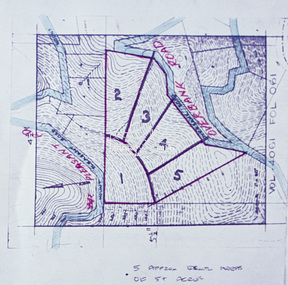
Slide - Photograph, Eltham Shire Council, Proposed subdivision of five approximately equal areas of 5 acres, Vol. 4061, Fol. 061, Overbank Road, North Warrandyte, 1969
... acres, Vol. 4061, Fol. 061, Overbank Road, North Warrandyte...North Warrandyte... Mount Pleasant Road North Warrandyte D4, 55341, Peck subdivision ...35mm colour positive transparency blue Agfacolour Service plastic mountD4, 55341, Peck subdivision, Mount Pleasant Road, 4 August 1969infrastructure, map, planning, subdivison lots, overbank road, mount pleasant road, north warrandyte -
 Eltham District Historical Society Inc
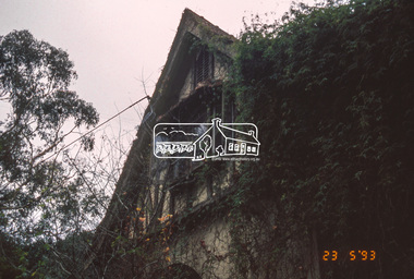
Slide - Photograph, The Robins. Kangaroo Ground-Warrandyte Road, North Warrandyte, 23 May 1993
... The Robins. Kangaroo Ground-Warrandyte Road, North...North Warrandyte.... Activities Kangaroo Ground-Warrandyte Road North Warrandyte Shire ...The 1993 Eltham Heritage Tour was enjoyed by a busload of members of the Historical Society on a fine, calm day, Sunday May 23rd. Between 10.00 am and 4.30 pm, except for a brief lunch stop at the Eltham Living and Learning Centre, members passed about thirty places of local interest and others recommended for the Historic Buildings Register and the Register of the National Estate. A number of significant trees and buildings were also highlighted along with the opportunity to explored some of the properties.35mm colour positive transparency (1 of 24) Mount - Kodak Kodachromeactivities, kangaroo ground-warrandyte road, north warrandyte, shire of eltham historical society, the robins, heritage excursion -
 Eltham District Historical Society Inc
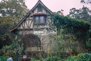
Slide - Photograph, The Robins. Kangaroo Ground-Warrandyte Road, North Warrandyte, 23 May 1993
... The Robins. Kangaroo Ground-Warrandyte Road, North...north warrandyte.... activities kangaroo ground-warrandyte road north warrandyte shire ...The 1993 Eltham Heritage Tour was enjoyed by a busload of members of the Historical Society on a fine, calm day, Sunday May 23rd. Between 10.00 am and 4.30 pm, except for a brief lunch stop at the Eltham Living and Learning Centre, members passed about thirty places of local interest and others recommended for the Historic Buildings Register and the Register of the National Estate. A number of significant trees and buildings were also highlighted along with the opportunity to explored some of the properties.35mm colour positive transparency (1 of 24) Mount - Kodak Kodachromeactivities, kangaroo ground-warrandyte road, north warrandyte, shire of eltham historical society, the robins, heritage excursion -
 Eltham District Historical Society Inc
Slide - Photograph, Stony Creek Road, North Warrandyte, c.1993
... Stony Creek Road, North Warrandyte...North Warrandyte... melbourne infrastructure roads Doleen Road North Warrandyte Stony ...35mm colour positive transparency Mount - Black and Whiteinfrastructure, roads, doleen road, north warrandyte, stony creek road -
 Eltham District Historical Society Inc
Slide - Photograph, Stony Creek Road, North Warrandyte, c.1993
... Stony Creek Road, North Warrandyte...north warrandyte... melbourne infrastructure roads doleen road north warrandyte stony ...35mm colour positive transparency Mount - Black and Whiteinfrastructure, roads, doleen road, north warrandyte, stony creek road -
 Eltham District Historical Society Inc
Slide - Photograph, Stony Creek Road, North Warrandyte, c.1993
... Stony Creek Road, North Warrandyte...North Warrandyte... melbourne infrastructure roads Doleen Road North Warrandyte Stony ...35mm colour positive transparency Mount - Black and Whiteinfrastructure, roads, doleen road, north warrandyte, stony creek road -
 Eltham District Historical Society Inc
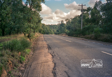
Photograph, Kangaroo Ground-Warrandyte Road, North Warrandyte, c.1988, 1988c
... Kangaroo Ground-Warrandyte Road, North Warrandyte, c.1988...North Warrandyte... North Warrandyte Fuji 100 Roll of 35mm colour negative film, 7 ...Looking southeast, Kruses Road on left.Roll of 35mm colour negative film, 7 stripsFuji 100eltham shire council, infrastructure, kangaroo ground-warrandyte road, kruses road, north warrandyte -
 Eltham District Historical Society Inc
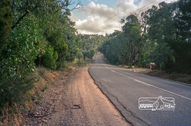
Photograph, Kangaroo Ground-Warrandyte Road, North Warrandyte, c.1988, 1988c
... Kangaroo Ground-Warrandyte Road, North Warrandyte, c.1988...north warrandyte... kangaroo ground-warrandyte road north warrandyte Fuji 100 Roll ...Looking northwest.Roll of 35mm colour negative film, 7 stripsFuji 100eltham shire council, infrastructure, kangaroo ground-warrandyte road, north warrandyte -
 Eltham District Historical Society Inc
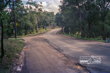
Photograph, Kangaroo Ground-Warrandyte Road, North Warrandyte, c.1988, 1988c
... Kangaroo Ground-Warrandyte Road, North Warrandyte, c.1988...north warrandyte... council infrastructure kangaroo ground-warrandyte road north ...Looking northwest, Floods Road on left.Roll of 35mm colour negative film, 7 stripsFuji 100eltham shire council, infrastructure, kangaroo ground-warrandyte road, north warrandyte, floods road -
 Eltham District Historical Society Inc
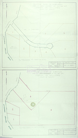
Slide - Photograph, Eltham Shire Council, Plan of Subdivision, Crown Allotment 8, Section 8A, Parish of Nillumbik,County of Evelyn, 1969
... North Warrandyte..., North Warrandyte, 4 August 1969... melbourne Carter Infrastructure Map North Warrandyte Pain Parish ...35mm colour positive transparency blue Agfacolour Service plastic mountC1, Pain, Sibbel and Carter, Research-Warrandyte Road, North Warrandyte, 4 August 1969carter, infrastructure, map, north warrandyte, pain, parish of nillumbik, plan of subdivision, planning, research-warrandyte road, sibbel, subdivison lots -
 Eltham District Historical Society Inc
Slide - Photograph, Eltham Shire Council, Tentative Plan of Subdivision, Part of Crown Allotment 20A and Part 20B, Parish of Nillumbik, County of Evelyn, 1969
... North Warrandyte... Road, North Warrandyte, 4 August 1969... Ground-Warrandyte Road North Warrandyte E2, N899, Young ...35mm colour positive transparency blue Agfacolour Service plastic mountE2, N899, Young subdivision, Kangaroo Ground-Warrandyte Road, North Warrandyte, 4 August 1969infrastructure, map, planning, subdivison lots, kangaroo ground-warrandyte road, north warrandyte -
 Nillumbik Shire Council
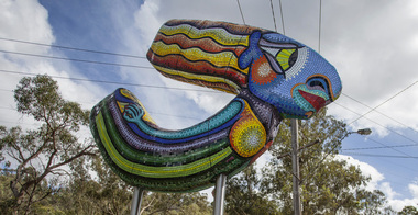
Public Art: Deborah HALPERN, 'Queen of the Shire'; Location: Cnr Kangaroo Ground-Warrandyte Rd & Research-Warrandyte Rd, North Warrandyte, 2015
... -Warrandyte Rd & Research-Warrandyte Rd, North Warrandyte...-Warrandyte Rd, North Warrandyte Public Art: Deborah HALPERN ...Deborah Halpern was raised in Nth Warrandyte. Her connection to the area and the significant contribution that she and her family (founding members of Potters Cottage) have made to the artistic heritage and culture of the Shire is acknowledge with the commission of this piece. Deborah Halpern is a highly recognised and respected local artist with an acclaimed national reputation in the arts community. This work is a gateway piece, welcoming residents and visitors into the Shire from the southern end of the boundary. 'Queen of the Shire' reflects the creative spirit that flows endlessly in the Shire, inspired by the landscape. This work forms part of a series of sculptures that Halpern has created along the banks of the Yarra in Melbourne ('Angel' - Birrarung Marr and 'Ophelia' - Southgate). This sculpture is an excellent example of Halpern’s ouvere and 'tile construction' technique for which she is renowned. Materials: coloured glass tiles, fibreglass, aluminium, steel. A sweeping stylised (female) form covered in bright and colourful tiles held aloft by two steel poles. queen, sculpture, semi-abstract, stylised, glass, tiles, public art, halpern, ek prac 2015 -
 Eltham District Historical Society Inc
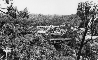
Photograph, View at Warrandyte, Vic, c.1937
... north warrandyte... present day 244 Research-Warrandyte Rd, North Warrandyte... present day 244 Research-Warrandyte Rd, North Warrandyte ...View looking southeast across the bridge to Warrandyte township. Taken from the northern side of the Yarra River from near present day 244 Research-Warrandyte Rd, North WarrandyteThis photo forms part of a collection of photographs gathered by the Shire of Eltham for their centenary project book,"Pioneers and Painters: 100 years of the Shire of Eltham" by Alan Marshall (1971). The collection of over 500 images is held in partnership between Eltham District Historical Society and Yarra Plenty Regional Library (Eltham Library) and is now formally known as the 'The Shire of Eltham Pioneers Photograph Collection.' It is significant in being the first community sourced collection representing the places and people of the Shire's first one hundred years.Digital image 4 x 5 inch B&W Negshire of eltham pioneers photograph collection, warrandyte, north warrandyte, warrandyte bridge -
 Eltham District Historical Society Inc
Photograph, The Robins, Warrandyte
... North Warrandyte..., North Warrandyte built of reinforced concrete for artist..., North Warrandyte built of reinforced concrete for artist ...The Robins (1913). 13 Kangaroo Ground-Warrandyte Road, North Warrandyte built of reinforced concrete for artist Theodore Penleigh Boyd, father of Robin Boyd. The Robins - Penleigh Boyd House Victorian Heritage Database (Shire of Nillumbik) https://vhd.heritagecouncil.vic.gov.au/places/63466Copy of black and white photographthe robins, houses, kangaroo ground-warrandyte road, north warrandyte, penleigh boyd, robin boyd -
 Eltham District Historical Society Inc
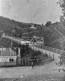
Photograph, Warrandyte Bridge on River Yarra
... North Warrandyte...Bridge across the Yarra River which links North Warrandyte... melbourne Bridge across the Yarra River which links North Warrandyte ...Bridge across the Yarra River which links North Warrandyte and Warrandyte. A house sits prominantly on a hill in the distance. A wooden building on the side of the road before the bridge has advertising for Wardrop Tailor, Smith Street, Collingwood. It is suggested that the photo has had this fake information added at a later date. Wardrop Tailor did operate from about 1915 to 1921. Alternataive title: Warrandyte Bridge - River Yarra. "Wardrop-Tailor, Smith St. C'wood" sign - faked?This photo forms part of a collection of photographs gathered by the Shire of Eltham for their centenary project book,"Pioneers and Painters: 100 years of the Shire of Eltham" by Alan Marshall (1971). The collection of over 500 images is held in partnership between Eltham District Historical Society and Yarra Plenty Regional Library (Eltham Library) and is now formally known as 'The Shire of Eltham Pioneers Photograph Collection.' It is significant in being the first community sourced collection representing the places and people of the Shire's first one hundred years.Digital imagesepp, shire of eltham pioneers photograph collection, warrandyte, bridge, north warrandyte, yarra river, wardrop tailor, collingwood -
 Ringwood and District Historical Society
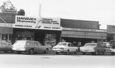
Photograph, North Ringwood Shopping Centre, Warrandyte Road, North Ringwood - July 1981
... North Ringwood Shopping Centre, Warrandyte Road, North... Shopping Centre, Warrandyte Road, North Ringwood - July 1981 ...Written on back of photograph, "The Family Chemist, North Ringwood Shopping Centre". -
 Ringwood and District Historical Society
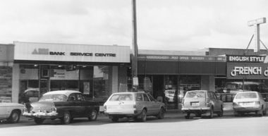
Photograph, North Ringwood Shopping Centre, Warrandyte Road, North Ringwood - July 1981
... North Ringwood Shopping Centre, Warrandyte Road, North...". North Ringwood Shopping Centre, Warrandyte Road, North Ringwood ...Written on back of photograph, "1-7-81. Norman's Hardware, North Ringwood Shopping Centre". -
 Ringwood and District Historical Society
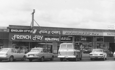
Photograph, North Ringwood Shopping Centre, Warrandyte Road, North Ringwood - July 1981
... North Ringwood Shopping Centre, Warrandyte Road, North... Shopping Centre, Warrandyte Road, North Ringwood - July 1981 ...Written on back of photograph, "1-7-81. North Ringwood Shopping Centre". -
 Ringwood and District Historical Society
Photograph, North Ringwood Shopping Centre, Warrandyte Road, North Ringwood, including North Ringwood Post Office Agency - July 1981
... North Ringwood Shopping Centre, Warrandyte Road, North...". North Ringwood Shopping Centre, Warrandyte Road, North Ringwood ...Written on back of photograph, "1-7-81. The Post Office, North Ringwood Shopping Centre". -
 Ringwood and District Historical Society
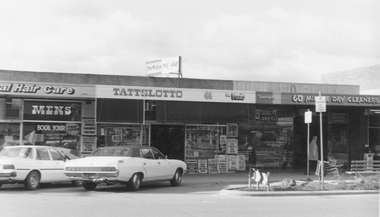
Photograph, North Ringwood Shopping Centre, Warrandyte Road, North Ringwood, including Green's Newsagency - July 1981
... North Ringwood Shopping Centre, Warrandyte Road, North...". North Ringwood Shopping Centre, Warrandyte Road, North Ringwood ...Written on back of photograph,"1-7-81. Greens Newsagency, North Ringwood Shopping Centre". -
 Nillumbik Shire Council
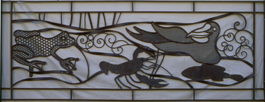
Deborah Halpern (b.1957 Melb) with Malcolm Laurence (b.1974 Melb), Malcolm Laurence, The Spirit of Nillumbik (balustrade panels x11); Location: Eltham Town Square - Main St, Eltham, 2001
... 7 Dingley Dell Road , North Warrandyte, Nillumbik ...In October 2000, Council invited three artists from the region (Deborah Halpern, Matcham Skipper, Tony Trembath) to submit designs for a sculpture / public art work for the Eltham Town Square. The commission was paid for by supermarket giant Safeway (Woolies) as part of its supermarket permit, which required them to contribute to beautification work in the Town Square.This is the first of three parts. The 'Spirit of Nillumbik' is a celebration of the artistic spirit of Eltham and surrounding communities. Each area is identified through the flora and fauna represented in the panels. The work honours the many creative artists and architects, past and present, who have built homes and shaped lives and livelihoods with their unique creative spirit. Halpern describes her work as a public expression of their individual and collective visions. Halpern acknowledges these contributions to our hand-made history and the influence they have on the character and identity of Eltham and Nillumbik. Five picture and six woven balustrades each made out of welded steel / organic wrought iron and coated with wax. Imagery (flora - plants, landscapes and fauna - animals, birds, reptiles, insects) are all based on the local environment. There is also a relevant aboriginal presence amongst each of the panels. Each panel represents the different areas that make up the Shire. 'Water' for Warrandyte, 'Kangaroos' for Christmas Hills, 'Cockatoos and 'Valley Creek Flats' for Hurstbridge, 'Wombats', 'Bluetongues' and 'Possums' for St. Andrews/Kinglake, 'Orchids' for Panton Hill, 'Cows' and 'Grapevines' for the Kangaroo Gound Hill landmark. N/Apublic art, nillumbik, fauna, flora, wrought iron, balustrade, halpern, laurence, kangaroo, eltham town square, spirit, warrandyte, christmas hills, kangaroo ground, hurstbridge, kinglake, panton hill, water, valley creek flats, cockatoos